


|
|
|
|
Paleoclimate Animation
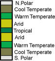
( To Run Animation, Drag Mouse Across Map ) This animation shows the changing location of the Earth's climatic belts through time. The legend to the left of the maps illustrates the position and width of the modern climatic belts. Notice how the climatic belts are more or less fixed. The continents move through the different belts. In the past, the width of the climatic belts has changed. When the Earth is in an Ice House phase, the Polar and Cool Temperate belts expand ( 0, 300, 630 million years ago). During Hot House times, the Arid and Warm Temperate belts expand (100, 200, & 400 million years ago). When the continents are gathered together in a Pangea, the wet tropical belt sometimes disappears. This animation is available on CD-ROM in Quicktime format. For more information see Teaching Materials. These plate reconstructions and paleoclimatic interpretations were
produced by the PALEOMAP Project.
This page uses a java applet that displays a VR model. Visit FreedomVR at www.honeylocust.com/vr/ for more information about this applet.
|
 Climatic Change